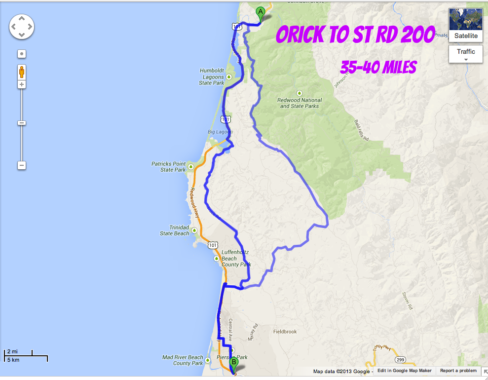


Be wary and excited about routes leaving out of Beaver only listed in google maps.

Leg 1 — Champoeg Park to Salem
All seasons; moderate traffic
The first leg of the Willamette Valley Scenic Bikeway, this section from Champoeg State Heritage Area to Salem is mostly flat, following country roads through rich agricultural land. It’s a pleasant route for meandering.
If you’re riding in the summer or fall, look for the hop fields; Oregon ranks second in the United States in hop production. Willamette Valley hops are shipped worldwide and are an important beer ingredient, especially in the Oregon style of IPA.
Be prepared for rain in the spring, late fall or winter; the valley is known for its wet climate then. Bicyclists with good rainwear and a positive attitude can have a good experience all year ’round. Snow is rare, with only a few light snowfalls per year, typically. April through November brings drier weather, lots of flowers and warm days, making them the best months to ride.
Leg 2 — Salem to Albany
All seasons; light to moderate traffic
This is the second leg of the Willamette Valley Scenic Bikeway. The ride from Salem to Buena Vista runs along the Willamette River and passes the Independence Bridge. A short detour over the bridge will take you into Independence. The town features a large downtown park, restaurants and a bed-and-breakfast. Monmouth, just west of Independence, is home to Western Oregon University, a motel and grocery stores.
South of the Independence Bridge, the route parallels the river and continues through the Ankeny Wildlife Refuge. Canada geese winter here, and their calls are usually the loudest noises heard on this stretch.
The route turns east to Jefferson, once the mint-growing capital of the world. The town has restaurants and a small grocery store, but no overnight accommodations. Just north of Albany the route passes by a paper mill. Expect an increase in traffic here.
Please note: Google Maps does not show the connection on Maple Avenue through Maple Park in Salem. Please refer to the Salem detail map for accurate route information.
Leg 3 — Albany to Brownsville
All seasons; moderate traffic
This is the third of four legs of the Willamette Valley Scenic Bikeway. Leaving Albany, the route quickly returns to a country setting south of the city. The route is generally quite flat and offers views of cultivated fields, acres of rye grass and the Willamette River. Whether you’re stopping here for the night or just passing through during a longer ride, Albany has a bicycle shop, plus many restaurants, hotels and B&Bs.
Leg 4 — Brownsville to Armitage Park
All seasons; moderate traffic
The final leg of the Willamette Valley Scenic Bikeway, this is also the most challenging. Before you set out, Brownsville has several nice cafés, a bakery and a city park with campsites. The town is a perfect place to relax on a bench on Main Street or in a café. While relaxing, ready your legs for the longest climb of the entire route, which begins just south of Brownsville. Once you crest the climb on Gap Road and descend the other side, the rest of the ride is a gradual uphill to your final destination, the scenic Armitage County Park. Other than the one big climb, this route is not that challenging.


WE'RE DOING THE OPPOSITE OF THIS:
“River Roller-Coaster”
Words you just don’t hear enough: “40-mile descent.” Start today with an incredible coasting/pedaling downhill along the river and through the woods, your path framed by big trees and rock walls. It’ll save your energy for the one big climb of the day, following a peaceful single-lane road for miles and punctuated by a grade of nearly 8 percent on the last stretch. Then rocket down to the flats for the final glide into Dorena Lake.

“Big Blue Bonus”
You can call it a layover day, but really it’s a bonus day. What else would you call the chance to ride possibly the most breathtaking loop road in the country? Crater Lake Rim Drive is one of the centerpiece rides you have to do if you want to say you’ve truly “ridden Oregon.” You can just pedal up to the rim and have a look at the lake, or go all the way around it. Either way it’s worth it. Yes, the loop route has nearly 6,500 feet of elevation gain, with four major climbs. But hey, you’ve got all day.


Day 1: Medford to Yreka (68 miles) – Starting from the hub of Southern Oregon, this day heads to Ashland, home of Shakespeare and a million interesting shops and restaurants. Outside town you get the chance to climb the Old Siskiyou Highway, a shady ride with far-reaching views at the top. Then it drops into California, down to Yreka.
NOTE: A portion of this route is on Interstate 5; there’s no other feasible way. The mapping program for this site won’t follow a freeway, so it shows differently here, but at the end of Old Highway 99, get on I-5 and follow it to the Hornbrook exit (Hornbrook Highway). The freeway shoulders are quite wide, but of course it’s busy and fast.
Day 1 map:Medford to Yreka
Day 2: Yreka to Happy Camp (74 miles) – Today you go deep into Jefferson, following the gorgeous Klamath River downstream basically all day and ending up in Happy Camp, a unique outpost if there ever was one.
Day 2 map:Yreka to Happy Camp
Day 3: Happy Camp to Lake Selmac (54 miles) – There’s only one way out of Happy Camp: up. It starts gradually for about 10 miles, and then shoots skyward for the next 10. The views are panoramic, and the descent down the other side is a scintillating test of your brakes and courage.